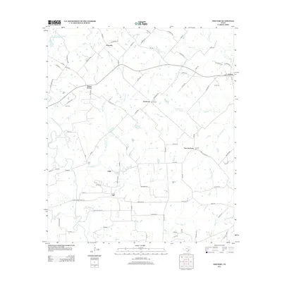
2013 Map of Industry
USGS Topo · Published 2013About this map
Agricultural clusters and family homesteads define this pocket of Central Texas, where small crossroads communities like Industry and Willow Springs remain anchored by a dense network of country roads. The landscape is carved by numerous tributaries including Willow Br, Poplar Cr, and Boggy Cr, which dictate the placement of farms and small settlements. Local genealogy is deeply etched into the terrain through family-named landmarks and resting places such as Knolle Cem, Albert Cem, and McElroy Cem. The map reveals a transition from these early agrarian hubs to modern rural management, exemplified by the Soil Conservation Service Site 26 Reservoir in the northwest corner. Smaller, more isolated points like Lone Oak, Pisek, and Krebsville appear as enduring markers of the area's original settlement patterns, connected by thoroughfares such as FM-109 and FM-1291.
Find a feature on this map
97 named features on this map. Tap any name to fly to it.
Don’t see what you’re looking for? This feature index may not catch every label — zoom into the map to look around manually.
Map Details
Editions of this 2013 Industry Map
This is the sole edition of this map. No revisions or reprints were ever made.
Other maps of this area

1919 · Fayettsville
USGS Topo · 1:62,500

1930 · Brenham
USGS Topo · 1:62,500

1953 · Seguin
USGS Topo · 1:250,000

1954 · Austin
USGS Topo · 1:250,000

1956 · Bellville
USGS Topo · 1:62,500

1956 · Brenham
USGS Topo · 1:62,500

1957 · Ellinger
USGS Topo · 1:24,000

1958 · Seguin
USGS Topo · 1:250,000

1958 · Industry
USGS Topo · 1:24,000

1958 · Greenvine
USGS Topo · 1:24,000