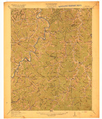
1916 Map of Inez
USGS Topo · Published 1916About this map
Inez (Eden) serves as the central hub of this 1914 survey, located at the confluence of the Middle Fork and Rockcastle Creek. The landscape is dominated by the winding path of the Levisa Fork, which carves through the terrain alongside the Chesapeake and Ohio railroad. This corridor facilitated the movement of coal and timber, supporting settlements like Whitehouse, Richardson, and Peach Orchard. The region's social fabric is evidenced by a dense network of numbered school districts and named institutions such as Justice School and Castle School.
Find a feature on this map
142 named features on this map. Tap any name to fly to it.
Don’t see what you’re looking for? This feature index may not catch every label — zoom into the map to look around manually.
Map Details
Editions of this 1916 Inez Map
3 editions found

Other maps of this area

1886 · Prestonsburg
USGS Topo · 1:125,000

1887 · Warfield
USGS Topo · 1:125,000

1891 · Warfield
USGS Topo · 1:125,000

1892 · Prestonsburg
USGS Topo · 1:125,000

1892 · Huntington
USGS Topo · 1:125,000

1898 · Huntington
USGS Topo · 1:125,000

1903 · Kenova
USGS Topo · 1:125,000

1904 · Kenova
USGS Topo · 1:125,000

1909 · Wayne
USGS Topo · 1:62,500

1910 · Naugatuck
USGS Topo · 1:48,000