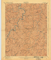
1916 Map of Inez
USGS Topo · Published 1932About this map
Inez Eden and the winding Rockcastle Creek anchor this survey of eastern Kentucky, conducted just before the United States entered the Great War. The landscape is defined by an intricate network of narrow hollows and ridge-top boundaries separating Lawrence, Johnson, and Martin counties. Evidence of the region's early 20th-century development is visible in the numerous small settlements like Whitehouse and Van Lear, alongside specialized post offices such as Graves Shoals Patrick P O and Chestnut Henrietta P O.
Find a feature on this map
140 named features on this map. Tap any name to fly to it.
Don’t see what you’re looking for? This feature index may not catch every label — zoom into the map to look around manually.
Map Details
Editions of this 1916 Inez Map
3 editions found

Other maps of this area

1886 · Prestonsburg
USGS Topo · 1:125,000

1887 · Warfield
USGS Topo · 1:125,000

1891 · Warfield
USGS Topo · 1:125,000

1892 · Prestonsburg
USGS Topo · 1:125,000

1892 · Huntington
USGS Topo · 1:125,000

1898 · Huntington
USGS Topo · 1:125,000

1903 · Kenova
USGS Topo · 1:125,000

1904 · Kenova
USGS Topo · 1:125,000

1909 · Wayne
USGS Topo · 1:62,500

1910 · Naugatuck
USGS Topo · 1:48,000