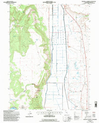
1993 Map of Infernal Caverns
USGS Topo · Published 1997About this map
Infernal Caverns Battleground Memorial Monument marks a significant historical site within this 1993 field-checked survey of Modoc County. The terrain is defined by the sharp transition from the elevated western ridges of Crooks Canyon down to the engineered valley floor of the South Fork Pit River. This lowland is dominated by a complex network of irrigation infrastructure, including the Westside Canal and Eastside Canal, reflecting the region's managed agricultural water system. To the south, Delta Lake and Alkali Lake provide seasonal water catchments in the basin. Evidence of early settlement and frontier history is preserved in labels for Graves near the Infernal Caverns and numerous family-named water sources such as Wade Williams Spring, which were vital for ranching operations in this high-desert landscape.
Find a feature on this map
19 named features on this map. Tap any name to fly to it.
Don’t see what you’re looking for? This feature index may not catch every label — zoom into the map to look around manually.
Map Details
Editions of this 1993 Infernal Caverns Map
This is the sole edition of this map. No revisions or reprints were ever made.
Other maps of this area

1886 · Alturas
USGS Topo · 1:250,000

1892 · Alturas
USGS Topo · 1:250,000

1954 · Alturas
USGS Topo · 1:250,000

1958 · Alturas
USGS Topo · 1:250,000

1961 · Alturas
USGS Topo · 1:62,500

1962 · Alturas
USGS Topo · 1:250,000

1962 · Tule Mountain
USGS Topo · 1:24,000

1962 · Likely
USGS Topo · 1:62,500

1963 · Little Juniper Reservoir
USGS Topo · 1:24,000

1963 · Dorris Reservoir
USGS Topo · 1:24,000