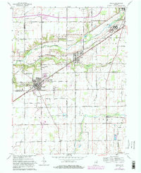
1962 Map of Ingalls
USGS Topo · Published 1982About this map
Fortville and Ingalls anchor this mid-century look at the tri-county border of Madison, Hancock, and Hamilton Counties. The era is defined by the Conrail line cutting through the central corridor, serving small rail-side communities like Alfont and supporting industrial outposts like the State Reformatory near the northern edge. Significant rural development is evident in the transition from traditional farming plots to residential pockets like Colonial Village and Sunview.
Find a feature on this map
48 named features on this map. Tap any name to fly to it.
Don’t see what you’re looking for? This feature index may not catch every label — zoom into the map to look around manually.
Map Details
Editions of this 1962 Ingalls Map
Other maps of this area

1952 · Cumberland
USGS Topo · 1:24,000

1952 · Greenfield
USGS Topo · 1:24,000

1952 · Ingalls
USGS Topo · 1:24,000

1952 · Mc Cordsville
USGS Topo · 1:24,000

1952 · Anderson
USGS Topo · 1:24,000

1953 · Pendleton
USGS Topo · 1:24,000

1953 · Lapel
USGS Topo · 1:24,000

1953 · Riverwood
USGS Topo · 1:24,000

1953 · Cincinnati
USGS Topo · 1:250,000

1953 · Muncie
USGS Topo · 1:250,000