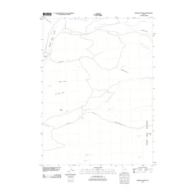
2011 Map of Ingham Canyon
USGS Topo · Published 2011About this map
Grouse Valley dominates the western portion of this Box Elder County landscape, where the seasonal waters of Grouse Creek and Pine Creek descend from the high peaks. The topography is defined by the sharp rise of the Grouse Creek Mountains to the east, anchored by the 9,130-foot Ingham Peak. Local history and family genealogy are centered near the Grouse Creek Cemetery in the northwest, situated along the Grouse Creek Rd corridor. This high-desert drainage system is marked by numerous named water sources essential for ranching and survival, including Cook Spring, Paskett Spring, and the North Bedke and South Bedke springs. Movement through the difficult terrain is facilitated by several named passes and canyons, most notably Ingham Canyon via Ingham Pass Rd, which cuts between the prominent Red Knolls and the mountain range's interior.
Find a feature on this map
31 named features on this map. Tap any name to fly to it.
Don’t see what you’re looking for? This feature index may not catch every label — zoom into the map to look around manually.
Map Details
Editions of this 2011 Ingham Canyon Map
This is the sole edition of this map. No revisions or reprints were ever made.
Other maps of this area

1954 · Brigham City
USGS Topo · 1:250,000

1958 · Brigham City
USGS Topo · 1:250,000
1959 · Cotton Thomas Basin
USGS Topo · 1:62,500
1959 · Yost
USGS Topo · 1:62,500

1962 · Brigham City
USGS Topo · 1:250,000
1971 · Emigrant Pass
USGS Topo · 1:24,000
1971 · Toms Cabin Spring
USGS Topo · 1:24,000
1971 · Potters Creek
USGS Topo · 1:24,000
1971 · Grouse Creek
USGS Topo · 1:24,000
1971 · Rocky Pass Peak
USGS Topo · 1:24,000