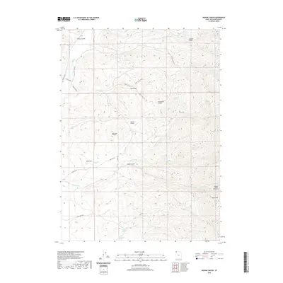
2020 Map of Ingham Canyon
USGS Topo · Published 2020About this map
The Grouse Creek Mountains dominate this high-desert terrain in Box Elder County, rising toward the prominent Ingham Peak in the southeast. This 2020 landscape is defined by its complex network of drainage basins and canyons, including Kimber Canyon, Cook Canyon, and Paskett Canyon. Water is the primary driver of name and movement here, with numerous vital water sources like Cook Spring, Red Knolls Spring, and South Bedke Spring scattered across the elevations. The transportation network is sparse, consisting of remote tracks like Red Butte Rd and Goose Creek Rd, which follow the contours of the land. These roads connect various springs and canyons, tracing historical pathways used by ranchers and early travelers through this high-altitude corner of northern Utah.
Find a feature on this map
33 named features on this map. Tap any name to fly to it.
Don’t see what you’re looking for? This feature index may not catch every label — zoom into the map to look around manually.
Map Details
Editions of this 2020 Ingham Canyon Map
This is the sole edition of this map. No revisions or reprints were ever made.
Other maps of this area

1954 · Brigham City
USGS Topo · 1:250,000

1958 · Brigham City
USGS Topo · 1:250,000
1959 · Cotton Thomas Basin
USGS Topo · 1:62,500
1959 · Yost
USGS Topo · 1:62,500

1962 · Brigham City
USGS Topo · 1:250,000
1971 · Emigrant Pass
USGS Topo · 1:24,000
1971 · Toms Cabin Spring
USGS Topo · 1:24,000
1971 · Potters Creek
USGS Topo · 1:24,000
1971 · Grouse Creek
USGS Topo · 1:24,000
1971 · Rocky Pass Peak
USGS Topo · 1:24,000