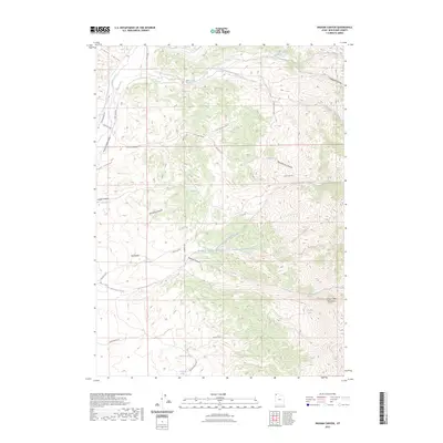
2023 Map of Ingham Canyon
USGS Topo · Published 2023About this map
The high ridges of the Grouse Creek Mountains dominate this western Box Elder County landscape, where water sources were critical for the early ranching and grazing operations that defined this remote region. Named springs such as Paskett Spring, Cook Spring, and Red Knolls Spring are scattered across the terrain, indicating the vital points of relief for livestock and travellers navigating the steep drainage systems of Kimber Canyon and Ingham Canyon. These natural landmarks often take their names from pioneer families, like the Paskett and Kimber names, preserving the human history of the high desert. The map traces the rugged Ingham Peak Ridge and follows the network of local routes like Cook Canyon Rd and Red Butte Rd, which connect the disparate water points and canyons across the high-elevation basins.
Find a feature on this map
36 named features on this map. Tap any name to fly to it.
Don’t see what you’re looking for? This feature index may not catch every label — zoom into the map to look around manually.
Map Details
Editions of this 2023 Ingham Canyon Map
This is the sole edition of this map. No revisions or reprints were ever made.
Other maps of this area

1954 · Brigham City
USGS Topo · 1:250,000

1958 · Brigham City
USGS Topo · 1:250,000

1959 · Cotton Thomas Basin
USGS Topo · 1:62,500

1959 · Yost
USGS Topo · 1:62,500

1962 · Brigham City
USGS Topo · 1:250,000

1971 · Emigrant Pass
USGS Topo · 1:24,000
1971 · Toms Cabin Spring
USGS Topo · 1:24,000

1971 · Potters Creek
USGS Topo · 1:24,000
1971 · Grouse Creek
USGS Topo · 1:24,000
1971 · Rocky Pass Peak
USGS Topo · 1:24,000