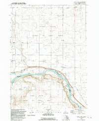
1992 Map of Initial Point
USGS Topo · Published 1992About this map
Initial Point serves as the literal foundation for land surveying in Idaho, marking the intersection of the Boise Meridian and the Base Line north of the Snake River. This 1992 revision reveals a landscape defined by the juxtaposition of high-desert geology and industrial irrigation efforts. Agricultural development is evident through the complex network of the Waldvogel Canal, Southern Lateral, and Summit Lateral, which draw water into the arid plains. Along the river canyon, the Birds Of Prey Natural Area encompasses the dramatic cliffs and basalt formations of Shea Basin. The map captures local land use at the end of the 20th century, from the remote Priest Ranch and various corrals to the industrial presence of Claypits and a Pumping Sta supporting the region's water management systems.
Find a feature on this map
31 named features on this map. Tap any name to fly to it.
Don’t see what you’re looking for? This feature index may not catch every label — zoom into the map to look around manually.
Map Details
Editions of this 1992 Initial Point Map
This is the sole edition of this map. No revisions or reprints were ever made.
Other maps of this area

1892 · Bisuka
USGS Topo · 1:125,000

1892 · Silver City
USGS Topo · 1:125,000

1894 · Bisuka
USGS Topo · 1:125,000

1894 · Silver City
USGS Topo · 1:125,000

1898 · Silver City
USGS Topo · 1:125,000

1947 · Wild Horse Butte
USGS Topo · 1:24,000

1948 · Wild Horse Butte
USGS Topo · 1:24,000

1948 · Sinker Butte
USGS Topo · 1:24,000

1949 · Sinker Butte
USGS Topo · 1:24,000

1949 · Oreana
USGS Topo · 1:62,500