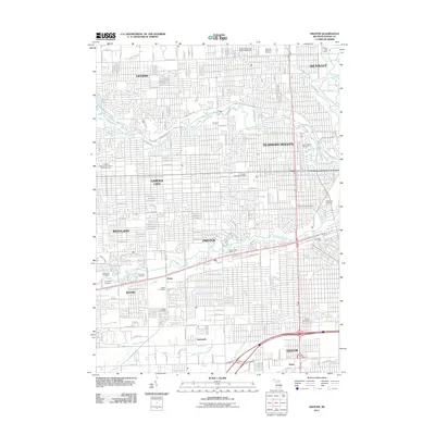
2011 Map of Inkster
USGS Topo · Published 2011About this map
The Lower River Rouge and its tributaries carve a winding path through this densely developed corridor of Wayne County, Michigan. The landscape is characterized by the convergence of several major Detroit suburbs, including Inkster, Garden City, and Westland, which are defined by an intricate grid of residential streets. A notable concentration of memorial sites and burial grounds serves as a focal point for local history and genealogy, from the National Memorial Gardens in the north to the Eloise Cemetery and Nowlin Cemetery further south. The drainage patterns of the area, represented by Ecorse River, Black Creek, and various man-made channels like McPhee Drain, underscore the region's managed hydrology. This survey also documents essential civic infrastructure, including the Dearborn Heights Post Office and the Redford Water and Sewer Department, alongside recreational spaces like the Rouge Golf Course and the parklands bordering Edward N Hines Dr.
Find a feature on this map
79 named features on this map. Tap any name to fly to it.
Don’t see what you’re looking for? This feature index may not catch every label — zoom into the map to look around manually.
Map Details
Editions of this 2011 Inkster Map
This is the sole edition of this map. No revisions or reprints were ever made.
Other maps of this area

1905 · Wayne
USGS Topo · 1:62,500

1905 · Detroit
USGS Topo · 1:62,500

1906 · Wyandotte
USGS Topo · 1:62,500

1906 · Romulus
USGS Topo · 1:62,500

1912 · Wyandotte
USGS Topo · 1:62,500

1912 · Wayne
USGS Topo · 1:62,500

1918 · Detroit
USGS Topo · 1:62,500

1924 · Detroit
USGS Topo · 1:62,500

1928 · Romulus
USGS Topo · 1:62,500

1929 · Wyandotte
USGS Topo · 1:62,500