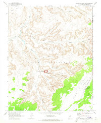
1970 Map of Inscription House Ruin
USGS Topo · Published 1973About this map
Inscription House Ruin serves as the focal point of this 1970 survey, situated within the Navajo National Monument in northern Arizona. The landscape is defined by a labyrinth of deep sandstone drainages, including Toenleshushe Canyon and Nitsin Canyon, which drop away from the Shonto Plateau. These canyons contain numerous cliff dwellings, indicating a complex history of indigenous habitation.
Find a feature on this map
26 named features on this map. Tap any name to fly to it.
Don’t see what you’re looking for? This feature index may not catch every label — zoom into the map to look around manually.
Map Details
Editions of this 1970 Inscription House Ruin Map
This is the sole edition of this map. No revisions or reprints were ever made.
Other maps of this area

1883 · Marsh Pass
USGS Topo · 1:250,000

1892 · Marsh Pass
USGS Topo · 1:250,000

1956 · Marble Canyon
USGS Topo · 1:250,000

1959 · Marble Canyon
USGS Topo · 1:250,000

1961 · Marble Canyon
USGS Topo · 1:250,000

1970 · Square Butte
USGS Topo · 1:24,000

1970 · Whirlwind Rock
USGS Topo · 1:24,000
1970 · Chaiyahi Rim SW
USGS Topo · 1:24,000
1970 · Two Red Mesas
USGS Topo · 1:24,000
1970 · Shonto
USGS Topo · 1:24,000