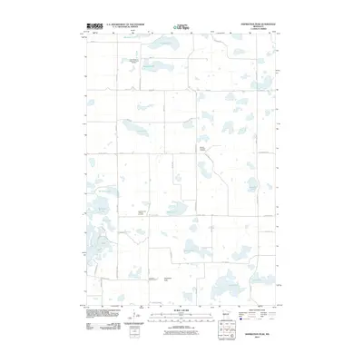
2010 Map of Inspiration Peak
USGS Topo · Published 2010About this map
Inspiration Peak anchors this landscape of glacial kettle lakes and rural townships in Otter Tail County. The map reveals a deeply rooted community structure, where gravel roads like Nidaros Church Dr and Lonely Oaks Dr connect scattered homesteads with local centers of worship and remembrance. The distribution of sites such as the Vestre Nidaaros Lutheran Church Cemetery and Leaf Mountain Lutheran Cemetery suggests the enduring legacy of Scandinavian settlement in the region. Water dominates the terrain, with dozens of named basins including Millpond Lake, Lake Jessie, and Long Lake defining the local geography. The layout of the road network, including County Hwy-57 and County Hwy-59, reflects a tradition of section-line surveying that has persisted since the nineteenth century, even as modern routes like Spitzer Lake Rd have been introduced to serve the shorelines.
Find a feature on this map
46 named features on this map. Tap any name to fly to it.
Don’t see what you’re looking for? This feature index may not catch every label — zoom into the map to look around manually.
Map Details
Editions of this 2010 Inspiration Peak Map
This is the sole edition of this map. No revisions or reprints were ever made.
Other maps of this area

1912 · Battle Lake
USGS Topo · 1:62,500

1914 · Battle Lake
USGS Topo · 1:62,500

1953 · Brainerd
USGS Topo · 1:250,000

1957 · Brainerd
USGS Topo · 1:250,000

1958 · Brainerd
USGS Topo · 1:250,000

1965 · Brainerd
USGS Topo · 1:250,000
1969 · Lake Miltona West
USGS Topo · 1:24,000

1969 · Henning
USGS Topo · 1:24,000

1969 · Eagle Lake
USGS Topo · 1:24,000
1969 · Parkers Prairie NW
USGS Topo · 1:24,000