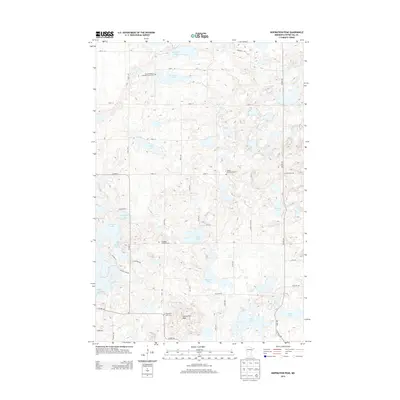
2013 Map of Inspiration Peak
USGS Topo · Published 2013About this map
Inspiration Peak anchors this corner of Otter Tail County, rising above a landscape defined by glacial kettle lakes and small rural congregations. The mapping captures a network of legacy Lutheran and Covenant burial grounds, including the Vestre Nidaaros Lutheran Church Cem and the Leaf Mtn Lutheran Cem, which speak to the area's Nordic settlement history. These sites are linked by a grid of local roads such as 160th St and Co Hwy-5 that navigate around a dense cluster of water bodies. Large basins like Spitzer Lake and Ellingson Lake dominate the northern and western sections, while smaller waters like Deusch Lake and Toms Lake fill the interior depressions. The absence of large town centers emphasizes the persistent agricultural and recreational character of this high-relief moraine country in the early 21st century.
Find a feature on this map
40 named features on this map. Tap any name to fly to it.
Don’t see what you’re looking for? This feature index may not catch every label — zoom into the map to look around manually.
Map Details
Editions of this 2013 Inspiration Peak Map
This is the sole edition of this map. No revisions or reprints were ever made.
Other maps of this area

1912 · Battle Lake
USGS Topo · 1:62,500

1914 · Battle Lake
USGS Topo · 1:62,500

1953 · Brainerd
USGS Topo · 1:250,000

1957 · Brainerd
USGS Topo · 1:250,000

1958 · Brainerd
USGS Topo · 1:250,000

1965 · Brainerd
USGS Topo · 1:250,000
1969 · Lake Miltona West
USGS Topo · 1:24,000

1969 · Henning
USGS Topo · 1:24,000

1969 · Eagle Lake
USGS Topo · 1:24,000
1969 · Parkers Prairie NW
USGS Topo · 1:24,000