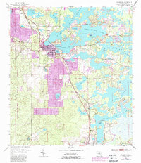
1954 Map of Inverness
USGS Topo · Published 1988About this map
Tsala Apopka Lake dominates the eastern half of this landscape, its intricate network of islands and interconnected water bodies like Henderson Lake and Freds Lake shaping the layout of central Citrus County. This mid-century topography, updated in the late 1980s, reveals a period of significant growth around Inverness, with purple revisions highlighting residential expansion between the historic town center and the shoreline of Cooter Lake.
Find a feature on this map
31 named features on this map. Tap any name to fly to it.
Don’t see what you’re looking for? This feature index may not catch every label — zoom into the map to look around manually.
Map Details
Editions of this 1954 Inverness Map
4 editions found
Other maps of this area

1893 · Panasoffkee
USGS Topo · 1:62,500

1895 · Tsala Apopka
USGS Topo · 1:62,500

1895 · Panasoffkee
USGS Topo · 1:62,500

1954 · Lecanto
USGS Topo · 1:24,000

1954 · Holder
USGS Topo · 1:24,000

1954 · Brooksville NW
USGS Topo · 1:24,000

1954 · Nobleton
USGS Topo · 1:24,000

1954 · Tsala Apopka NE
USGS Topo · 1:24,000

1954 · Inverness
USGS Topo · 1:24,000

1954 · Inverness
USGS Topo · 1:62,500