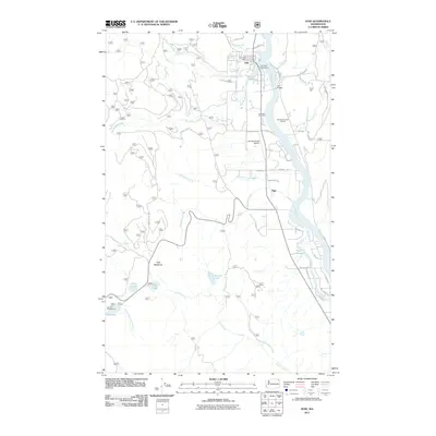
2011 Map of Ione
USGS Topo · Published 2011About this map
The Pend Oreille River flows northward through this portion of northeast Washington, anchoring the town of Ione and the smaller settlement of Tiger. The landscape reflects a legacy of river-based industry and mountain transit, evidenced by the Ione Millpond and its associated Ione Mill Pond Dam situated just north of the Ione Bridge. Local genealogy and land use are marked by features like the Riverside Cemetery and the Ione Pit, while the Ione Municipal Airport sits on a plateau above the river valley. Further south, the terrain transitions into a mosaic of alpine lakes and meadows including Tiger Meadows, Lake Leo, and Frater Lake, highlighting the region's dense network of small water bodies and creeks like Lost Creek and Renshaw Creek.
Find a feature on this map
47 named features on this map. Tap any name to fly to it.
Don’t see what you’re looking for? This feature index may not catch every label — zoom into the map to look around manually.
Map Details
Editions of this 2011 Ione Map
This is the sole edition of this map. No revisions or reprints were ever made.
Other maps of this area

1929 · Colville
USGS Topo · 1:125,000

1933 · Colville
USGS Topo · 1:125,000

1934 · Metaline
USGS Topo · 1:125,000

1942 · Metaline
USGS Topo · 1:125,000

1952 · Deep Lake
USGS Topo · 1:24,000

1958 · Sandpoint
USGS Topo · 1:250,000

1963 · Sandpoint
USGS Topo · 1:250,000
1966 · Lake Gillette
USGS Topo · 1:24,000
1967 · Aladdin Mtn
USGS Topo · 1:24,000

1967 · Timber Mtn.
USGS Topo · 1:24,000