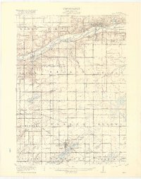
1918 Map of Ionia
USGS Topo · Published 1918About this map
The Grand River carves a deep valley across this Michigan landscape, anchoring the bustling county seat of Ionia where the State Reformatory and State Prison overlook the water. This 1918 edition documents a region defined by its rail-and-river economy, with the Grand Trunk and Pere Marquette railroads threading through towns like Saranac and South Ionia. To the south, the terrain flattens into a rich patchwork of section lines and small settlements such as Lake Odessa and Clarksville.
Find a feature on this map
86 named features on this map. Tap any name to fly to it.
Don’t see what you’re looking for? This feature index may not catch every label — zoom into the map to look around manually.
Map Details
Editions of this 1918 Ionia Map
2 editions found
Other maps of this area

1916 · Ionia
USGS Topo · 1:62,500

1918 · Ionia
USGS Topo · 1:62,500

1918 · Lowell
USGS Topo · 1:62,500

1943 · Ionia
USGS Topo · 1:62,500

1943 · Lowell
USGS Topo · 1:62,500

1945 · Portland
USGS Topo · 1:62,500

1949 · Charlotte
USGS Topo · 1:62,500

1950 · Nashville
USGS Topo · 1:62,500

1951 · Nashville
USGS Topo · 1:62,500

1951 · Hastings
USGS Topo · 1:62,500