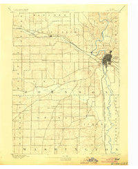
1891 Map of Iowa City
USGS Topo · Published 1904About this map
Iowa City serves as the focal point of this late 19th-century survey, shown as a dense grid of streets along the Iowa River. The landscape is characterized by a high density of watercourses, with Old Man Creek winding through the southern townships and Clear Creek cutting across the central portion of the county. The early rail infrastructure is prominent, featuring the Chicago Rock Island and Pacific Railroad running west through Tiffin and the Burlington Cedar Rapids and Northern Railroad tracking south through Pleasant Valley. These routes, along with settlements like Coralville and South Liberty, illustrate the transport-driven growth patterns of Johnson County before the modern highway era. The detailed topography by W.J. Peters captures the numerous small drainages such as Pardee Creek and Rapid Creek that shaped the agricultural layout of the surrounding townships.
Find a feature on this map
23 named features on this map. Tap any name to fly to it.
Don’t see what you’re looking for? This feature index may not catch every label — zoom into the map to look around manually.
Map Details
Editions of this 1891 Iowa City Map
3 editions found
Other maps of this area

1887 · Cedar Rapids
USGS Topo · 1:62,500

1888 · Amana
USGS Topo · 1:62,500

1889 · Amana
USGS Topo · 1:62,500

1891 · Oxford
USGS Topo · 1:62,500

1891 · Mechanicsville
USGS Topo · 1:62,500

1891 · Cedar Rapids
USGS Topo · 1:62,500

1891 · Iowa City
USGS Topo · 1:62,500

1894 · Mechanicsville
USGS Topo · 1:62,500

1894 · Oxford
USGS Topo · 1:62,500

1894 · West Liberty
USGS Topo · 1:62,500