1891 Map of Iowa City
USGS Topo · Published 1926About this map
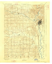
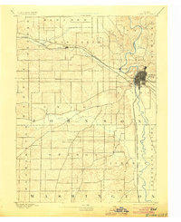
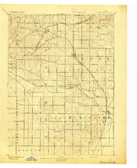
Iowa City stands as the central hub of this late-19th-century landscape, positioned at a critical junction where river valleys and pioneering rail lines intersect. The map reveals the early urban grid of the city alongside the neighboring settlement of Coralville to the west. Two major iron arteries, the Chicago Rock Island and Pacific Railroad and the Burlington Cedar Rapids and Northern Railroad, define the regional transport corridors, facilitating movement between the rural townships and the growing city center. Beyond the town limits, the topography is shaped by the meandering courses of Old Man Creek and Clear Creek, which carve through the undulating terrain of Johnson County. Small village clusters like Tiffin and South Liberty represent the agricultural and social centers for the surrounding farmsteads before the modern expansion of the twentieth century.
Find a feature on this map
24 named features on this map. Tap any name to fly to it.
Don’t see what you’re looking for? This feature index may not catch every label — zoom into the map to look around manually.
Map Details
Editions of this 1891 Iowa City Map
3 editions found
Other maps of this area

1887 · Cedar Rapids
USGS Topo · 1:62,500

1888 · Amana
USGS Topo · 1:62,500

1889 · Amana
USGS Topo · 1:62,500

1891 · Oxford
USGS Topo · 1:62,500

1891 · Mechanicsville
USGS Topo · 1:62,500

1891 · Cedar Rapids
USGS Topo · 1:62,500

1891 · Iowa City
USGS Topo · 1:62,500

1894 · Mechanicsville
USGS Topo · 1:62,500

1894 · Oxford
USGS Topo · 1:62,500
1894 · West Liberty
USGS Topo · 1:62,500