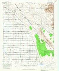
1940 Map of Iris
USGS Topo · Published 1967About this map
Irrigation infrastructure and military boundaries define this desert landscape, where the Coachella Canal and East High Line Canal cut through the arid terrain. Based on 1940 aerial photography, the map documents a precisely gridded system of lateral canals named for flora, from Nectarine Canal to Magnolia Canal, supporting agricultural efforts near the Alamo River. Small rail-dependent settlements and sidings like Iris, Tortuga, and Flowing Well Siding follow the route of the Southern Pacific railroad, while the eastern portion is dominated by the Chocolate Mountain Aerial Gunnery Range and the Chocolate Mountains. Local social life is anchored by landmarks such as the Mulberry Sch and rural outposts like Munyon. The transition from the cultivated East Mesa to the desert floor of Mammoth Wash reveals the stark divide between human engineering and the natural environment at the start of the 1940s.
Find a feature on this map
58 named features on this map. Tap any name to fly to it.
Don’t see what you’re looking for? This feature index may not catch every label — zoom into the map to look around manually.
Map Details
Editions of this 1940 Iris Map
4 editions found
Other maps of this area

1907 · Holtville
USGS Topo · 1:125,000

1915 · El Centro
USGS Topo · 1:125,000

1940 · Brawley
USGS Topo · 1:62,500

1940 · Iris
USGS Topo · 1:62,500

1940 · Frink
USGS Topo · 1:62,500

1940 · Iris Pass
USGS Topo · 1:62,500

1940 · Alamorio
USGS Topo · 1:62,500

1942 · El Centro
USGS Topo · 1:250,000

1943 · Brawley
USGS Topo · 1:62,500

1944 · Calipatria
USGS Topo · 1:62,500