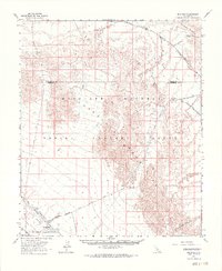
1963 Map of Iris Pass
USGS Topo · Published 1969About this map
The Coachella East Mesa Canal cuts across the arid landscape of the Colorado Desert in this mid-1960s survey, marking a stark line between the irrigated lowlands and the rugged Chocolate Mountains. This territory was defined by military and industrial utility, dominated by the massive Aerial Gunnery Range and various naval and government reservations. Traces of older transit and extraction are visible throughout, from the historic Bradshaw Road to the Imperial Buttes Mine.
Find a feature on this map
31 named features on this map. Tap any name to fly to it.
Don’t see what you’re looking for? This feature index may not catch every label — zoom into the map to look around manually.
Map Details
Editions of this 1963 Iris Pass Map
2 editions found
Other maps of this area

1940 · Iris
USGS Topo · 1:62,500

1940 · Frink
USGS Topo · 1:62,500

1940 · Iris Pass
USGS Topo · 1:62,500

1940 · Canyon Spring
USGS Topo · 1:62,500

1943 · Canyon Spring
USGS Topo · 1:62,500

1944 · Chuckwalla Mountains
USGS Topo · 1:62,500

1944 · Calipatria
USGS Topo · 1:62,500

1944 · Frink
USGS Topo · 1:62,500

1945 · Iris Pass
USGS Topo · 1:62,500

1945 · Iris
USGS Topo · 1:62,500