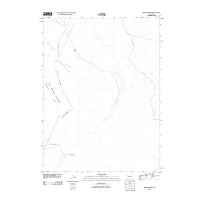
2010 Map of Irish Canyon
USGS Topo · Published 2010About this map
Cold Springs Mountain Ridge dominates the western landscape of this Moffat County quadrant, where the narrow passage of Irish Canyon cuts through the high desert terrain. The area is defined by a sparse ranching and water-management network, centered around Ink Spring Ranch in the south and the ephemeral Irish Lakes to the north. Drainage patterns are vital to this arid environment, with the winding path of Vermillion Creek and the seasonal Dry Creek carving distinct paths across the basin.
Find a feature on this map
11 named features on this map. Tap any name to fly to it.
Don’t see what you’re looking for? This feature index may not catch every label — zoom into the map to look around manually.
Map Details
Editions of this 2010 Irish Canyon Map
This is the sole edition of this map. No revisions or reprints were ever made.
Other maps of this area

1954 · Vernal
USGS Topo · 1:250,000

1958 · Vernal
USGS Topo · 1:250,000

1960 · Vernal
USGS Topo · 1:250,000

1966 · G Spring
USGS Topo · 1:24,000

1966 · Sugarloaf Butte
USGS Topo · 1:24,000

1966 · Big Joe Basin
USGS Topo · 1:24,000
1966 · Sparks
USGS Topo · 1:24,000

1966 · Irish Canyon
USGS Topo · 1:24,000

1966 · Sheephead Basin
USGS Topo · 1:24,000

1966 · Hiawatha
USGS Topo · 1:24,000