
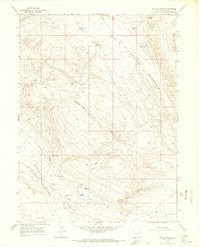
1966 Map of Big Joe Basin
USGS Topo · Published 1969About this map
Browns Park and the surrounding high country of northwestern Colorado define this 1966 topographic study. The landscape is dominated by the massive Cold Spring Mountain and the distinct topographic divide of Limestone Ridge. Settled patterns are sparse, focusing instead on seasonal water sources like Pablo Spring, Matt Spring, and Swede Spring that supported livestock in this arid basin. A small genealogical landmark, the Bassett Cem, sits near the base of the mountains, suggesting the early homesteading history of the area.
Find a feature on this map
29 named features on this map. Tap any name to fly to it.
Don’t see what you’re looking for? This feature index may not catch every label — zoom into the map to look around manually.
Map Details
Editions of this 1966 Big Joe Basin Map
2 editions found
Other maps of this area

1954 · Lodore School
USGS Topo · 1:24,000

1954 · Canyon of Lodore North
USGS Topo · 1:24,000

1954 · Vernal
USGS Topo · 1:250,000

1958 · Vernal
USGS Topo · 1:250,000

1960 · Vernal
USGS Topo · 1:250,000

1966 · Sugarloaf Butte
USGS Topo · 1:24,000
1966 · Beaver Basin
USGS Topo · 1:24,000
1966 · Sparks
USGS Topo · 1:24,000

1966 · Irish Canyon
USGS Topo · 1:24,000
1966 · Jack Springs
USGS Topo · 1:24,000