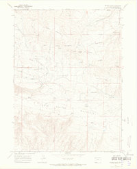
1966 Map of Beaver Basin
USGS Topo · Published 1969About this map
Middle Mountain and Cold Spring Mountain dominate this high-altitude landscape in northwestern Colorado, where the 1966 terrain is defined by a complex network of seasonal drainages and springs. The map documents the high-country grazing infrastructure of the mid-20th century, specifically the Buckley Cow Camp near the headwaters of My Valley. This remote corner of Moffat County serves as a transition point between state lines, bordering the Utah State Line to the west and the Wyoming-Colorado border to the north. Numerous water sources such as Spitzie Spring, Talamantes Creek, and Antelope Spring are crucial markers for local land use and stock management. The presence of Rocky Reservoir and a system of jeep trails indicate the essential, though sparse, human presence required to manage these upland meadows and peaks like Diamond Peak.
Find a feature on this map
37 named features on this map. Tap any name to fly to it.
Don’t see what you’re looking for? This feature index may not catch every label — zoom into the map to look around manually.
Map Details
Editions of this 1966 Beaver Basin Map
3 editions found
Other maps of this area

1885 · Ashley
USGS Topo · 1:250,000

1952 · Willow Creek Butte
USGS Topo · 1:24,000

1952 · Swallow Canyon
USGS Topo · 1:24,000

1954 · Lodore School
USGS Topo · 1:24,000

1954 · Vernal
USGS Topo · 1:250,000

1954 · Rock Springs
USGS Topo · 1:250,000

1958 · Vernal
USGS Topo · 1:250,000

1958 · Rock Springs
USGS Topo · 1:250,000

1960 · Vernal
USGS Topo · 1:250,000

1962 · Rock Springs
USGS Topo · 1:250,000