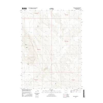
2016 Map of Irish Canyon
USGS Topo · Published 2016About this map
Irish Canyon and the high elevations of Cold Spring Mtn anchor this northwestern Colorado landscape. The topography is defined by significant drainage systems, specifically the winding course of Vermillion Cr and its tributary, Dry Cr. The area is characterized by dramatic elevation changes, notably along Limestone Ridge and near Blue Hill. Transport through this arid terrain relies on a few established routes like Co RD 10n and Co RD 169. While large settlements are absent, the map documents seasonal water features such as the Irish Lakes and localized depressions like Teds Draw, providing a detailed study of the high-desert environment before modern land-use changes.
Find a feature on this map
16 named features on this map. Tap any name to fly to it.
Don’t see what you’re looking for? This feature index may not catch every label — zoom into the map to look around manually.
Map Details
Editions of this 2016 Irish Canyon Map
This is the sole edition of this map. No revisions or reprints were ever made.
Other maps of this area

1954 · Vernal
USGS Topo · 1:250,000

1958 · Vernal
USGS Topo · 1:250,000

1960 · Vernal
USGS Topo · 1:250,000
1966 · G Spring
USGS Topo · 1:24,000
1966 · Sugarloaf Butte
USGS Topo · 1:24,000
1966 · Big Joe Basin
USGS Topo · 1:24,000
1966 · Sparks
USGS Topo · 1:24,000
1966 · Irish Canyon
USGS Topo · 1:24,000
1966 · Sheephead Basin
USGS Topo · 1:24,000
1966 · Hiawatha
USGS Topo · 1:24,000