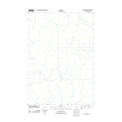
2012 Map of Irish Creek SE
USGS Topo · Published 2012About this map
The sparsely populated plains of Ziebach County are defined by a network of seasonal watercourses in this early twenty-first-century survey. The terrain is characterized by the winding path of Irish Cr and its tributary, E Irish Cr, which drain the open landscape toward the northeast. In the upper corner of the map, Red Earth Cr cuts through the prairie, illustrating the drainage patterns that have historically dictated land use and ranching boundaries in this portion of South Dakota. The survey highlights a grid of section roads and rural routes that navigate the subtle elevation changes of the western river breaks, providing a clear record of the area's infrastructure and natural hydrology before further modern development.
Find a feature on this map
3 named features on this map. Tap any name to fly to it.
Don’t see what you’re looking for? This feature index may not catch every label — zoom into the map to look around manually.
Map Details
Editions of this 2012 Irish Creek SE Map
This is the sole edition of this map. No revisions or reprints were ever made.
Other maps of this area

1951 · Dupree NE
USGS Topo · 1:24,000

1951 · Thunder Butte
USGS Topo · 1:24,000

1952 · Lantry NW
USGS Topo · 1:24,000

1953 · McIntosh
USGS Topo · 1:250,000

1958 · McIntosh
USGS Topo · 1:250,000

1978 · Isabel SW
USGS Topo · 1:24,000

1978 · Isabel
USGS Topo · 1:24,000

1982 · Irish Creek SW
USGS Topo · 1:24,000
1982 · Irish Creek NW
USGS Topo · 1:24,000
1982 · Irish Creek SE
USGS Topo · 1:24,000