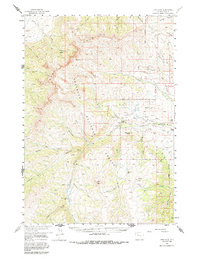
1957 Map of Irish Rock
USGS Topo · Published 1987About this map
The Shoshone National Forest dominates this landscape, defined by high-altitude ranching and remote mountain outposts in the mid-1950s. The Greybull River carves through the central valley, serving as a lifeline for isolated homesteads such as Palette Ranch No 1 and Homestead Ranch. High-country navigation relies on routes like the Warhouse Trail, which skirts the steep slopes of Carter Mountain and Phelps Mtn. The map records a series of seasonal or remote shelters including Jack Creek Cabin and Venus Creek Cabin, reflecting the area's legacy of range management and wilderness trekking. From the heights of Irish Rock to the bowl of Aldrich Basin, the drainage patterns of Aldrich Creek and Jack Creek illustrate a complex watershed before it reaches the lower agricultural valleys.
Find a feature on this map
38 named features on this map. Tap any name to fly to it.
Don’t see what you’re looking for? This feature index may not catch every label — zoom into the map to look around manually.
Map Details
Editions of this 1957 Irish Rock Map
3 editions found

Other maps of this area

1893 · Ishawooa
USGS Topo · 1:125,000

1895 · Ishawooa
USGS Topo · 1:125,000

1899 · Ishawooa
USGS Topo · 1:125,000

1904 · Kirwin
USGS Topo · 1:125,000

1905 · Younts Peak
USGS Topo · 1:125,000

1906 · Kirwin
USGS Topo · 1:125,000

1907 · Younts Peak
USGS Topo · 1:125,000

1955 · Cody
USGS Topo · 1:250,000

1955 · Thermopolis
USGS Topo · 1:250,000

1956 · Emerald Lake
USGS Topo · 1:24,000