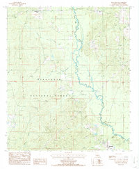
1986 Map of Iron Branch
USGS Topo · Published 1986About this map
The Dugdemona River snakes through the heart of the Kisatchie National Forest in this mid-1980s topographic study of Winn Parish. The landscape is defined by its riparian network, where major tributaries like Cypress Creek and the namesake Iron Branch feed into the river valley. Human activity is concentrated around small established points like Brewtons Mill in the northwest and Bethlehem to the southeast, connected by a network of unimproved roads and a prominent pipeline corridor.
Find a feature on this map
18 named features on this map. Tap any name to fly to it.
Don’t see what you’re looking for? This feature index may not catch every label — zoom into the map to look around manually.
Map Details
Editions of this 1986 Iron Branch Map
This is the sole edition of this map. No revisions or reprints were ever made.
Other maps of this area

1947 · Goldonna
USGS Topo · 1:62,500

1949 · Calvin NE
USGS Topo · 1:31,680

1949 · Calvin NW
USGS Topo · 1:31,680

1949 · Jonesboro
USGS Topo · 1:62,500

1950 · Jonesboro
USGS Topo · 1:62,500

1950 · Winnfield
USGS Topo · 1:62,500

1951 · Winnfield
USGS Topo · 1:62,500

1953 · Alexandria
USGS Topo · 1:250,000

1955 · Shreveport
USGS Topo · 1:250,000

1955 · Alexandria
USGS Topo · 1:250,000