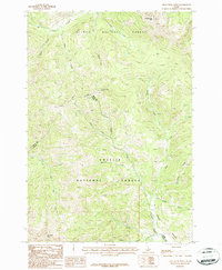
1987 Map of Iron Creek Point
USGS Topo · Published 1987About this map
The boundary between Salmon National Forest and Challis National Forest bisects this high-elevation landscape, where the ridge lines define the border between Lemhi and Custer counties. Significant peaks such as Timber Creek Peak and the namesake Iron Creek Point anchor a terrain defined by steep drainage basins and narrow mountain passes like Timber Creek Pass. Evidence of historical exploration is noted through several mineral workings, including a Prospect Adit and various other prospects located on the slopes above Timber Creek. The hydrology of the area is dominated by the upper reaches of Big Timber Creek and Sawmill Creek, with a single Campground providing a rare point of human infrastructure among the canyons and creeks. This 1987 provisional survey serves as a record of the wilderness just as it was being formally digitized and updated.
Find a feature on this map
23 named features on this map. Tap any name to fly to it.
Don’t see what you’re looking for? This feature index may not catch every label — zoom into the map to look around manually.
Map Details
Editions of this 1987 Iron Creek Point Map
This is the sole edition of this map. No revisions or reprints were ever made.
Other maps of this area

1935 · Borah Peak
USGS Topo · 1:125,000

1938 · Borah Peak
USGS Topo · 1:125,000

1955 · Dubois
USGS Topo · 1:250,000

1956 · Leadore
USGS Topo · 1:62,500

1956 · Patterson
USGS Topo · 1:62,500

1956 · Donkey Hills
USGS Topo · 1:62,500

1957 · Gilmore
USGS Topo · 1:62,500

1958 · Dubois
USGS Topo · 1:250,000

1980 · Leadore
USGS Topo · 1:100,000

1987 · Gilmore
USGS Topo · 1:24,000