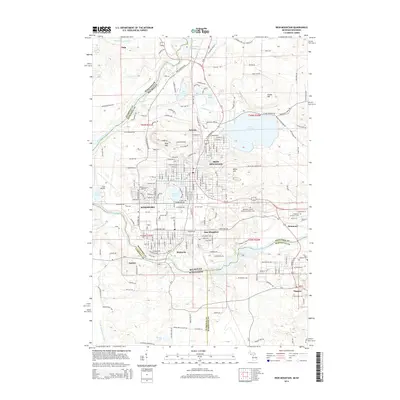
2014 Map of Iron Mountain
USGS Topo · Published 2014About this map
The Menominee River serves as the winding border between Michigan and Wisconsin, anchoring the industrial and residential development of Iron Mountain and Kingsford. This area, deeply rooted in the mining and manufacturing history of the Upper Peninsula, is defined by significant terrain and industry markers like Pine Mtn and the site of the Chapin Mine. The map reveals a landscape heavily influenced by water management and power, featuring the Twin Falls Flowage, Hydraulic Falls, and Horserace Rapids.
Find a feature on this map
145 named features on this map. Tap any name to fly to it.
Don’t see what you’re looking for? This feature index may not catch every label — zoom into the map to look around manually.
Map Details
Editions of this 2014 Iron Mountain Map
This is the sole edition of this map. No revisions or reprints were ever made.
Other maps of this area

1939 · Pembine
USGS Topo · 1:48,000

1939 · Dunbar
USGS Topo · 1:48,000

1939 · Iron Mountain
USGS Topo · 1:48,000

1941 · Dunbar
USGS Topo · 1:48,000

1941 · Iron Mountain
USGS Topo · 1:48,000

1947 · Pembine
USGS Topo · 1:48,000

1947 · Dunbar
USGS Topo · 1:48,000

1947 · Iron Mountain
USGS Topo · 1:48,000
1949 · Commonwealth
USGS Topo · 1:24,000

1954 · Iron Mountain
USGS Topo · 1:250,000