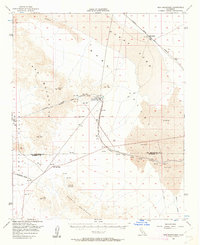
1956 Map of Iron Mountains
USGS Topo · Published 1962About this map
Infrastructure for the transport of water and freight dominates this 1950s landscape within the Mojave Desert. The Colorado River Aqueduct is the central engineering marvel shown, featuring the Iron Mountain Pumping Plant and a series of complex structures including the West Iron Portal, a siphon, and tunnels through the Iron Mountains. These features reflect California's mid-century push for water security through the Director of Water Resources.
Find a feature on this map
26 named features on this map. Tap any name to fly to it.
Don’t see what you’re looking for? This feature index may not catch every label — zoom into the map to look around manually.
Map Details
Editions of this 1956 Iron Mountains Map
3 editions found

Other maps of this area

1942 · Blythe
USGS Topo · 1:250,000

1942 · Amboy
USGS Topo · 1:250,000

1943 · Amboy
USGS Topo · 1:250,000

1943 · Cadiz Lake
USGS Topo · 1:62,500

1943 · Cadiz Valley
USGS Topo · 1:62,500

1943 · Turtle Mts.
USGS Topo · 1:62,500

1943 · Iron Mountains
USGS Topo · 1:62,500

1943 · Coxcomb Mountains
USGS Topo · 1:62,500

1944 · Coxcomb Mountains
USGS Topo · 1:62,500

1945 · Midland
USGS Topo · 1:62,500