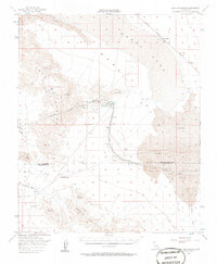
1956 Map of Iron Mountains
USGS Topo · Published 1984About this map
Infrastructure for the Metropolitan Water District of Southern California dominates this mid-century desert landscape, centered on the Iron Mountain Pumping Plant and the Colorado River Aqueduct. The survey captures a vital lifeline of water engineering, featuring details like the Sand Draw Siphon, Siphons, and various Water Tanks that sustained operations in the arid Ward Valley. This technological corridor is framed by the steep rises of the Iron Mountains and the Granite Mountains, connected by the high passage at Granite Pass. To the northeast, the Atchison Topeka and Santa Fe railroad skirts the edge of Danby Lake, passing through the small station at Saltmarsh. The map meticulously tracks the San Bernardino Base Line and the county boundary between San Bernardino and Riverside Counties, documenting a remote region defined by its role in regional water transport.
Find a feature on this map
30 named features on this map. Tap any name to fly to it.
Don’t see what you’re looking for? This feature index may not catch every label — zoom into the map to look around manually.
Map Details
Editions of this 1956 Iron Mountains Map
3 editions found

Other maps of this area

1942 · Blythe
USGS Topo · 1:250,000

1942 · Amboy
USGS Topo · 1:250,000

1943 · Amboy
USGS Topo · 1:250,000

1943 · Cadiz Lake
USGS Topo · 1:62,500

1943 · Cadiz Valley
USGS Topo · 1:62,500

1943 · Turtle Mts.
USGS Topo · 1:62,500

1943 · Iron Mountains
USGS Topo · 1:62,500

1943 · Coxcomb Mountains
USGS Topo · 1:62,500

1944 · Coxcomb Mountains
USGS Topo · 1:62,500

1945 · Midland
USGS Topo · 1:62,500