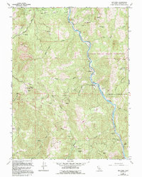
1967 Map of Iron Peak
USGS Topo · Published 1994About this map
The Round Valley Indian Reservation occupies the eastern half of this terrain, its boundary following the winding course of the Eel River. This mid-century survey illustrates a landscape of rugged canyons and high summits, notably Iron Peak, which is topped by the Iron Peak Lookout Tower. Smaller settlements and family-named landmarks are scattered throughout the river valley and along the ridges, including Nashmead, Woodman, and the Ralph Leggett Place.
Find a feature on this map
38 named features on this map. Tap any name to fly to it.
Don’t see what you’re looking for? This feature index may not catch every label — zoom into the map to look around manually.
Map Details
Editions of this 1967 Iron Peak Map
3 editions found
Other maps of this area

1920 · Cummings
USGS Topo · 1:62,500

1920 · Covelo
USGS Topo · 1:62,500

1921 · Branscomb
USGS Topo · 1:62,500

1951 · Branscomb
USGS Topo · 1:62,500

1951 · Laytonville
USGS Topo · 1:62,500

1952 · Spyrock
USGS Topo · 1:62,500

1952 · Leggett
USGS Topo · 1:62,500

1957 · Ukiah
USGS Topo · 1:250,000

1960 · Ukiah
USGS Topo · 1:250,000
1967 · Covelo West
USGS Topo · 1:24,000