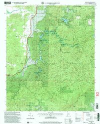
2001 Map of Ironaton
USGS Topo · Published 2004About this map
The Talladega National Forest dominates this portion of the Alabama landscape, where the ridges of the Appalachian foothills meet small, dispersed communities. This 2001 revision illustrates the complex topography surrounding Ironaton and McElderry, regions historically defined by their relationship to the land's natural resources and the drainage of Cheaha Creek. The presence of numerous rural congregations, such as Smith Chapel, Seay Chapel, and Mt Calvary Ch, alongside scattered cemeteries and gravesites, provides a clear view of the social geography of these mountain communities at the start of the 21st century.
Find a feature on this map
36 named features on this map. Tap any name to fly to it.
Don’t see what you’re looking for? This feature index may not catch every label — zoom into the map to look around manually.
Map Details
Editions of this 2001 Ironaton Map
This is the sole edition of this map. No revisions or reprints were ever made.
Other maps of this area

1889 · Springville
USGS Topo · 1:125,000

1890 · Talladega
USGS Topo · 1:125,000

1891 · Ashland
USGS Topo · 1:125,000

1892 · Springville
USGS Topo · 1:125,000

1892 · Talladega
USGS Topo · 1:125,000

1900 · Anniston
USGS Topo · 1:125,000

1943 · Talladega
USGS Topo · 1:62,500

1946 · Talladega
USGS Topo · 1:62,500

1947 · Oxford
USGS Topo · 1:24,000

1947 · Eastaboga
USGS Topo · 1:24,000