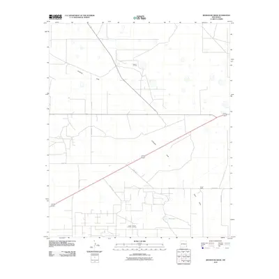
2010 Map of Ironhouse Draw
USGS Topo · Published 2010About this map
Pearl Valley defines this section of Lea County, where the landscape is characterized by its arid terrain and the industrial footprint of the Reeves Oil Field. The ephemeral drainage of Ironhouse Draw cuts diagonally across the quadrangle, leading toward the distinct basin of Red Lake in the southeast. This 2010 survey highlights a sparsely populated region where life and history are anchored by family names and livestock operations, such as the Turner Ranch. Genealogists and local historians will find significant value in the documentation of the Crockett Cemetery and Morgan Cemetery, which stand as quiet markers of the community's early residents. The network of local infrastructure, including Pearl Valley Rd and various county routes, illustrates the enduring connection between ranching and resource extraction in this part of New Mexico.
Find a feature on this map
12 named features on this map. Tap any name to fly to it.
Don’t see what you’re looking for? This feature index may not catch every label — zoom into the map to look around manually.
Map Details
Editions of this 2010 Ironhouse Draw Map
This is the sole edition of this map. No revisions or reprints were ever made.
Other maps of this area

1954 · Hobbs
USGS Topo · 1:250,000

1958 · Hobbs
USGS Topo · 1:250,000

1962 · Lovington
USGS Topo · 1:62,500

1962 · Buckeye
USGS Topo · 1:62,500

1963 · Monument
USGS Topo · 1:62,500

1963 · Laguna Gatuna
USGS Topo · 1:62,500

1984 · Lea
USGS Topo · 1:24,000

1984 · Ironhouse Well
USGS Topo · 1:24,000
1985 · Monument North
USGS Topo · 1:24,000
1985 · Lovington SE
USGS Topo · 1:24,000