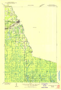
1943 Map of Ironwood
USGS Topo · Published 1950About this map
The Montreal River forms the winding interstate boundary between Wisconsin and Michigan, anchoring a landscape shaped by iron mining and timber during the early 1940s. The dense industrial core near Hurley and Montreal gives way to a network of rural schools like South Carey Sch and Defer Sch, reflecting the community structure of the Gogebic Range. Further south, the map documents the infrastructure of the logging era at the Mosinee Lumber Camp and the watchpoint at the Pine Lake Fire Tower.
Find a feature on this map
42 named features on this map. Tap any name to fly to it.
Don’t see what you’re looking for? This feature index may not catch every label — zoom into the map to look around manually.
Map Details
Editions of this 1943 Ironwood Map
2 editions found
Other maps of this area

1939 · Winchester
USGS Topo · 1:48,000

1940 · Mercer
USGS Topo · 1:48,000

1940 · Butternut
USGS Topo · 1:48,000

1940 · Upson
USGS Topo · 1:48,000

1943 · Little Girls Point
USGS Topo · 1:24,000

1943 · Upson
USGS Topo · 1:48,000

1943 · Ironwood
USGS Topo · 1:48,000

1943 · Little Girl Point
USGS Topo · 1:48,000

1945 · Mercer
USGS Topo · 1:48,000

1946 · Winchester
USGS Topo · 1:48,000