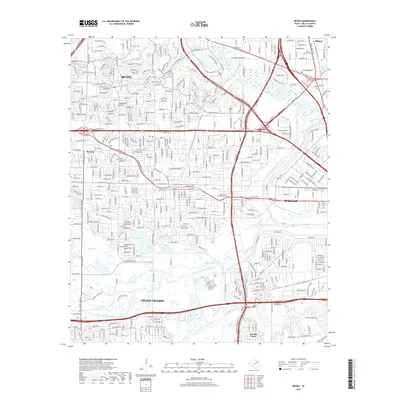
2019 Map of Irving
USGS Topo · Published 2019About this map
Irving and the surrounding suburban sprawl of Dallas and Grand Prairie define this late 2010s landscape. The complex intersection of the West Fork Trinity River and Elm Fork Trinity River creates a corridor of natural drainage and wetlands, including Bear Slough and the wide Vilbig Lakes. Historic footprints are preserved in small pockets like Sowers and the residential grid of Arcadia Park near Chalk Hill. Local history and genealogy are anchored by several notable burial sites, such as Sowers Cem, Smith Cem, and the Dallas City Cem. The infrastructure of the Dallas-Fort Worth metroplex is on full display, with major thoroughfares like W Airport Fwy and W Irving Blvd cutting through the densely developed neighborhoods and industrial zones near Oldham.
Find a feature on this map
67 named features on this map. Tap any name to fly to it.
Don’t see what you’re looking for? This feature index may not catch every label — zoom into the map to look around manually.
Map Details
Editions of this 2019 Irving Map
This is the sole edition of this map. No revisions or reprints were ever made.
Other maps of this area

1891 · Dallas
USGS Topo · 1:125,000

1893 · Dallas
USGS Topo · 1:125,000

1894 · Fort Worth
USGS Topo · 1:125,000

1925 · Dallas 2-b
USGS Topo · 1:48,000

1931 · Carrollton
USGS Topo · 1:62,500

1931 · Grapevine
USGS Topo · 1:62,500

1954 · Dallas
USGS Topo · 1:250,000

1958 · Dallas
USGS Topo · 1:250,000

1958 · Oak Cliff
USGS Topo · 1:24,000

1958 · Dallas
USGS Topo · 1:24,000