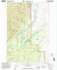
1997 Map of Isaac Meadows
USGS Topo · Published 2002About this map
Beaverhead National Forest lands dominate this late-twentieth-century landscape, where industrial extraction and ranching intersect across the drainage of Ruby Creek. The map documents a cluster of mining activity centered around Nickel Bar Gulch, including the Ruby Mine and the Moose Horn Mine, alongside several other unnamed prospects and a Gravel Pit. These features indicate a history of mineral exploration tucked into the steep drainages of Badger Ridge and Wenger Gulch.
Find a feature on this map
26 named features on this map. Tap any name to fly to it.
Don’t see what you’re looking for? This feature index may not catch every label — zoom into the map to look around manually.
Map Details
Editions of this 1997 Isaac Meadows Map
This is the sole edition of this map. No revisions or reprints were ever made.
Other maps of this area

1955 · Dillon
USGS Topo · 1:250,000

1957 · Dillon
USGS Topo · 1:250,000

1958 · Dillon
USGS Topo · 1:250,000

1962 · Dillon
USGS Topo · 1:250,000

1965 · Dillon
USGS Topo · 1:250,000

1966 · Gibbons School
USGS Topo · 1:24,000

1966 · Shewag Lake
USGS Topo · 1:24,000

1966 · Big Hole Battlefield
USGS Topo · 1:24,000

1966 · Jumbo Mountain
USGS Topo · 1:24,000

1966 · Big Hole Pass
USGS Topo · 1:24,000