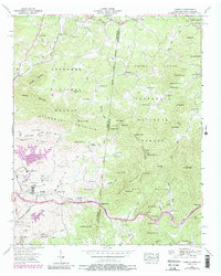
1957 Map of Isabella
USGS Topo · Published 1988About this map
Isabella Mine and the nearby London Flotation Plant anchor a landscape defined by the industrial extraction of the Copper Basin during the mid-twentieth century. This survey documents the concentrated mining activity along the Louisville and Nashville rail corridor, featuring the McPherson Mine, Eureka Mine, and Calloway Mines. While heavy industry dominates the lowlands near the settlement of Isabella, the surrounding heights of the Cherokee National Forest and Nantahala National Forest are dotted with rural family-centric landmarks like Burger Town and McGeetown. A unique cultural presence is found on the ridge near the North Carolina border, where the Fields of the Wood and a massive Ten Commandments display are marked. The terrain is marked by numerous small churches and cemeteries, such as Croft Chapel and Neal Chapel Cem, providing essential points of interest for genealogists tracing local families in this border region.
Find a feature on this map
95 named features on this map. Tap any name to fly to it.
Don’t see what you’re looking for? This feature index may not catch every label — zoom into the map to look around manually.
Map Details
Editions of this 1957 Isabella Map
4 editions found
Other maps of this area

1888 · Ellijay
USGS Topo · 1:125,000

1892 · Ellijay
USGS Topo · 1:125,000

1893 · Murphy
USGS Topo · 1:125,000

1898 · Ellijay
USGS Topo · 1:125,000

1911 · Ellijay
USGS Topo · 1:125,000

1914 · Murphy
USGS Topo · 1:125,000

1934 · Persimmon Creek
USGS Topo · 1:24,000

1934 · Unaka
USGS Topo · 1:24,000

1934 · Murphy
USGS Topo · 1:48,000

1935 · Epworth
USGS Topo · 1:24,000