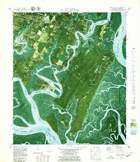
1979 Map of Isle of Hope
USGS Topo · Published 1979About this map
Isle of Hope and the surrounding coastal islands defined the maritime character of this Georgia landscape in the late 1970s. The map illustrates a complex network of waterways, including the Skidaway River and Vernon River, which isolate and shape the residential and protected lands. Of particular interest to local historians is the Wormsloe Plantation Historic Site, a significant regional landmark located near the Bethesda Home for Boys.
Find a feature on this map
77 named features on this map. Tap any name to fly to it.
Don’t see what you’re looking for? This feature index may not catch every label — zoom into the map to look around manually.
Map Details
Editions of this 1979 Isle of Hope Map
3 editions found
Other maps of this area

1920 · Wassaw Sound
USGS Topo · 1:62,500

1920 · Bluffton
USGS Topo · 1:62,500

1942 · Savannah
USGS Topo · 1:62,500

1944 · Ossabaw Island
USGS Topo · 1:62,500

1945 · Bluffton
USGS Topo · 1:62,500

1945 · Ossabaw Island
USGS Topo · 1:62,500

1945 · Wassaw Sound
USGS Topo · 1:62,500

1946 · Brunswick
USGS Topo · 1:250,000

1947 · Savannah
USGS Topo · 1:250,000

1948 · Brunswick
USGS Topo · 1:250,000