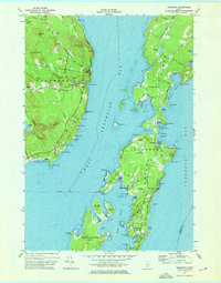
1973 Map of Islesboro
USGS Topo · Published 1976About this map
The waters of West Penobscot Bay surround the long, narrow silhouette of Islesboro in the early 1970s. This survey illustrates the island's unique geography, tied to the mainland at Northport by the Islesboro Ferry Toll arriving at Grindel Pt. The settlement pattern follows the Main Road, stretching from the cluster at North Islesboro down to the refined enclave of Dark Harbor near Ames Cove. To the west, the smaller Seven Hundred Acre Island and Warren Island frame the deep anchorage of Gilkey Harbor. On the mainland, Durham State Forest and landmarks like Knowlton Hill define the coast above Saturday Cove. This era shows a landscape where maritime tradition and summer estates coexist, evident in the proximity of the Public Landing to the Islesboro Municipal Airport and the local Central Sch.
Find a feature on this map
100 named features on this map. Tap any name to fly to it.
Don’t see what you’re looking for? This feature index may not catch every label — zoom into the map to look around manually.
Map Details
Editions of this 1973 Islesboro Map
2 editions found
Other maps of this area

1902 · Castine
USGS Topo · 1:62,500

1904 · Castine
USGS Topo · 1:62,500

1904 · Vinalhaven
USGS Topo · 1:62,500

1904 · Rockland
USGS Topo · 1:62,500

1905 · Penobscot Bay
USGS Topo · 1:125,000

1906 · Rockland
USGS Topo · 1:62,500

1915 · Belfast
USGS Topo · 1:62,500

1917 · Belfast
USGS Topo · 1:62,500

1941 · Belfast
USGS Topo · 1:62,500

1941 · Rockland
USGS Topo · 1:62,500