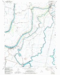
1978 Map of Isleton
USGS Topo · Published 1993About this map
Isleton and the riverfront communities of Walnut Grove and Locke anchor this map of the California Delta, where the Sacramento River and Mokelumne River diverge into a complex web of sloughs and island tracts. The landscape is a product of intensive hydrological engineering, featuring the Delta Cross Channel and numerous pumping stations that manage the low-lying terrain of Grand Island, Andrus Island, and Tyler Island. The presence of the Rio Vista Gas Field and West Thornton-Walnut Grove Gas Field highlights the region's importance beyond agriculture, showing a reliance on natural resource extraction.
Find a feature on this map
42 named features on this map. Tap any name to fly to it.
Don’t see what you’re looking for? This feature index may not catch every label — zoom into the map to look around manually.
Map Details
Editions of this 1978 Isleton Map
3 editions found
Other maps of this area

1894 · Lodi
USGS Topo · 1:125,000

1908 · Courtland
USGS Topo · 1:62,500

1910 · New Hope
USGS Topo · 1:31,680

1910 · Rio Vista
USGS Topo · 1:31,680

1910 · Bouldin
USGS Topo · 1:31,680

1910 · Jersey
USGS Topo · 1:31,680

1910 · Bruceville
USGS Topo · 1:31,680

1910 · Headreach
USGS Topo · 1:31,680

1910 · Isleton
USGS Topo · 1:31,680

1916 · Cache Slough
USGS Topo · 1:31,680