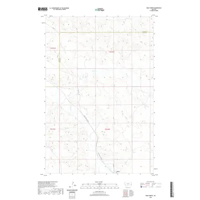
2020 Map of Ismay North
USGS Topo · Published 2020About this map
O'Fallon Cr winds through this cattle-country landscape near the Custer County and Prairie County line. The settlement of Ismay sits at the southern edge of the sheet, serving as a focal point for the surrounding ranching and agricultural operations. The drainage network is particularly detailed, showing the seasonal flow patterns of Pennel Cr, Lone Tree Cr, and Malone Cr as they cut through the undulating plains. Transportation across these distances is facilitated by rural arteries like Ismay Rd and the descriptively named Mildred Ismay Cut Across. This 2020 update provides a contemporary look at land use in a region where topography and water access have long dictated the rhythm of rural life and property boundaries.
Find a feature on this map
15 named features on this map. Tap any name to fly to it.
Don’t see what you’re looking for? This feature index may not catch every label — zoom into the map to look around manually.
Map Details
Editions of this 2020 Ismay North Map
This is the sole edition of this map. No revisions or reprints were ever made.
Other maps of this area
1953 · Miles City
USGS Topo · 1:250,000
1957 · Miles City
USGS Topo · 1:250,000
1958 · Miles City
USGS Topo · 1:250,000
1981 · Baker
USGS Topo · 1:100,000
1981 · Mildred NE
USGS Topo · 1:24,000
1981 · Bracket Butte
USGS Topo · 1:24,000
1981 · Loony Hollow
USGS Topo · 1:24,000
1981 · Ismay North
USGS Topo · 1:24,000
1981 · Dorothy Draw
USGS Topo · 1:24,000
1981 · Ayer Spring
USGS Topo · 1:24,000