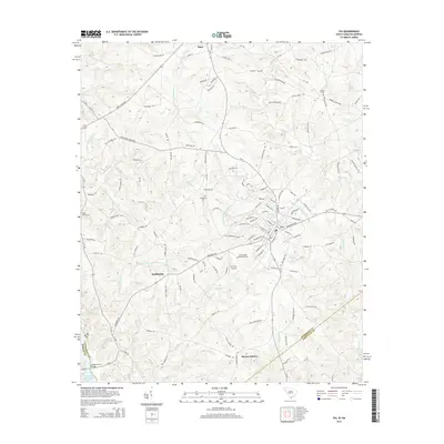
2014 Map of Iva
USGS Topo · Published 2014About this map
Iva serves as the primary hub of this Anderson County landscape, where the local road network converges at the town center. The settlement patterns reflect a rural economy shaped by proximity to the Savannah River basin, most notably evidenced by the southwest portion of the map where Richard B Russell Lake meets the Sanders Ferry Bridge. Several historic burial grounds, including Hebron Cem, Goodhope Cem, and Poplar Spring Cem, are distributed across the countryside, often located near small communities like Starr or Moffitsville. The topography is defined by the branching tributaries of Little Generostee Cr and Wilson Cr, which create a complex system of ridges and valleys. Small-scale infrastructure such as the Iva Field Airport and the intersection at Barnes Station highlight the region's development during the early 21st century, while family names on local roads suggest deep-rooted land ownership in this corner of the South Carolina Piedmont.
Find a feature on this map
126 named features on this map. Tap any name to fly to it.
Don’t see what you’re looking for? This feature index may not catch every label — zoom into the map to look around manually.
Map Details
Editions of this 2014 Iva Map
This is the sole edition of this map. No revisions or reprints were ever made.
Other maps of this area

1893 · Elberton
USGS Topo · 1:125,000

1954 · Greenville
USGS Topo · 1:250,000

1958 · Greenville
USGS Topo · 1:250,000

1958 · Elberton
USGS Topo · 1:62,500

1959 · Hartwell Dam
USGS Topo · 1:24,000

1959 · Hartwell NE
USGS Topo · 1:24,000

1964 · Iva
USGS Topo · 1:24,000

1964 · Antreville
USGS Topo · 1:24,000

1964 · Lowndesville
USGS Topo · 1:24,000

1964 · Saylors Crossroads
USGS Topo · 1:24,000