
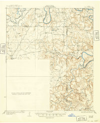
1931 Map of Ivan
USGS Topo · Published 1931About this map
The Brazos River carves a dramatic series of oxbow bends across this territory at the junction of Young, Stephens, and Palo Pinto counties. In the mid-1920s, the landscape was defined by small rural schoolhouses and isolated settlements, reflecting a transition from open ranching to established farming and early petroleum activity. Communities like South Bend and Oil City sit near the river's northern reach, while scattered educational centers such as Duff Prairie Sch and Ming Bend Sch served the dispersed population. The terrain south of the river turns to a dense network of hollows and ridges, including Billiehunt Hollow and Bear Hollow, which converge toward the Caddo Creek drainage. Notable elevations like Ball Mtn and Hayrick Mtn provide landmarks across a topography that, during this era, was just beginning to be documented with the help of aerial photography from the Army Air Corps.
Find a feature on this map
35 named features on this map. Tap any name to fly to it.
Don’t see what you’re looking for? This feature index may not catch every label — zoom into the map to look around manually.
Map Details
Editions of this 1931 Ivan Map
2 editions found
Other maps of this area

1890 · Breckenridge
USGS Topo · 1:125,000

1891 · Palo Pinto
USGS Topo · 1:125,000

1918 · Palo Pinto
USGS Topo · 1:125,000

1924 · Breckenridge 1-a
USGS Topo · 1:48,000

1924 · Palo Pinto 2-b
USGS Topo · 1:48,000

1924 · Graham 4-d
USGS Topo · 1:48,000

1924 · Palo Pinto 2-c
USGS Topo · 1:48,000

1924 · Breckenridge 1-d
USGS Topo · 1:48,000

1925 · Graham 4-c
USGS Topo · 1:48,000

1925 · Breckenridge 1-b
USGS Topo · 1:48,000