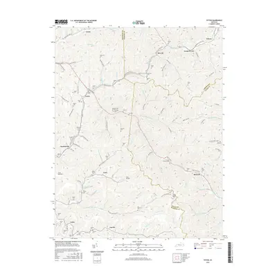
2016 Map of Ivyton
USGS Topo · Published 2016About this map
Ivyton and Brainard anchor this 2016 study of the hollows and ridge-lines where Magoffin, Johnson, and Floyd counties meet. The landscape is defined by its deep genealogical imprint, evidenced by numerous family-named burial grounds such as the Boone Howard Cem, Hackworth and Spradling Cem, and Salyers Cem. The transition from industrial rail use to modern recreation is marked by the Dawkins Line Rail Trail, which traces the former rail corridor through Riceville and Swamp Branch. To the south, settlements like Gapville and Galdia sit along the winding Salt Lick Br, while the peak of Little Half Mtn provides a distinct geographical landmark. The dense network of cemeteries and small communities like Gypsy and Coon Hollow reflects a persistent Appalachian settlement pattern focused on the narrow valleys of Middle Cr Louisa Fork and its many tributaries.
Find a feature on this map
121 named features on this map. Tap any name to fly to it.
Don’t see what you’re looking for? This feature index may not catch every label — zoom into the map to look around manually.
Map Details
Editions of this 2016 Ivyton Map
This is the sole edition of this map. No revisions or reprints were ever made.
Other maps of this area

1886 · Prestonsburg
USGS Topo · 1:125,000

1889 · Salyersville
USGS Topo · 1:125,000

1891 · Salyersville
USGS Topo · 1:125,000

1892 · Prestonsburg
USGS Topo · 1:125,000

1899 · Salyersville
USGS Topo · 1:125,000

1915 · Paintsville
USGS Topo · 1:48,000

1915 · Prestonsburg
USGS Topo · 1:62,500

1917 · Paintsville
USGS Topo · 1:62,500

1918 · Prestonsburg
USGS Topo · 1:62,500

1951 · Tiptop
USGS Topo · 1:24,000