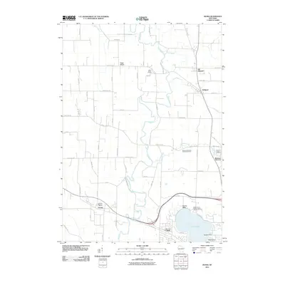
2010 Map of Ixonia
USGS Topo · Published 2010About this map
The Rock River meanders through this portion of Jefferson and Dodge counties, shaping a landscape of agricultural roads and concentrated settlements at the dawn of the 21st century. The map illustrates the distinct locations of Old Ashippun and its southern neighbor Ashippun, while the community of Monterey sits at the confluence of the Ashippun River and Davy Creek. This area is particularly rich in genealogical data, preserving several religious and community burial sites such as the Saint Marks Cemetery, Monterey Village Cemetery, and the Redemptionist Fathers Catholic Seminary Cemetery near the shores of Lac La Belle. To the southwest, the town of Ixonia is anchored by Glenview Memorial Gardens, while geographic features like Sugar Island and Beggs Island suggest the marshy, river-bottom character of the terrain that has historically dictated local road patterns and land use.
Find a feature on this map
64 named features on this map. Tap any name to fly to it.
Don’t see what you’re looking for? This feature index may not catch every label — zoom into the map to look around manually.
Map Details
Editions of this 2010 Ixonia Map
This is the sole edition of this map. No revisions or reprints were ever made.
Other maps of this area

1892 · Watertown
USGS Topo · 1:62,500

1892 · Oconomowoc
USGS Topo · 1:62,500

1894 · Watertown
USGS Topo · 1:62,500

1904 · Hartford
USGS Topo · 1:62,500

1909 · Oconomowoc
USGS Topo · 1:62,500

1955 · Horicon
USGS Topo · 1:62,500

1957 · Madison
USGS Topo · 1:250,000
1959 · Helenville
USGS Topo · 1:24,000

1959 · Ixonia
USGS Topo · 1:24,000
1959 · Oconomowoc East
USGS Topo · 1:24,000