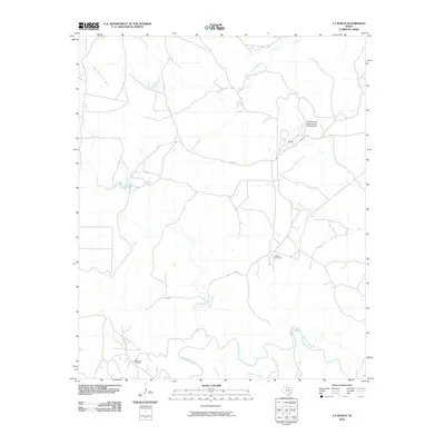
2010 Map of J Y Ranch
USGS Topo · Published 2010About this map
JY Ranch and its extensive cattle-raising operations dominate this North Texas landscape, where the Middle Fork Wichita River and the South Wichita River carve through the plains. The ranch's infrastructure is prominently marked, including the JY Ranch South Camp and the private JY Ranch-R B Masterson III Estate Airport, signaling the scale of this historic holding. To the south, the Bateman Oil Field indicates the region's intersection of ranching and energy production. Several local drainages, such as Willow Creek, Bird Creek, and Newman Creek, provide water for livestock across a territory managed via rural routes like Co RD 251 and Co RD 257.
Find a feature on this map
11 named features on this map. Tap any name to fly to it.
Don’t see what you’re looking for? This feature index may not catch every label — zoom into the map to look around manually.
Map Details
Editions of this 2010 J Y Ranch Map
This is the sole edition of this map. No revisions or reprints were ever made.
Other maps of this area

1954 · Lubbock
USGS Topo · 1:250,000

1966 · Ox Yoke Creek
USGS Topo · 1:24,000

1966 · Chalk SW
USGS Topo · 1:24,000

1966 · J Y Ranch
USGS Topo · 1:24,000

1966 · Lowrance Mountain
USGS Topo · 1:24,000

1967 · Dark Canyon
USGS Topo · 1:24,000

1967 · Fourmile Hill
USGS Topo · 1:24,000
1967 · Buzzard Peak
USGS Topo · 1:24,000

1968 · Grow
USGS Topo · 1:24,000

1968 · Guthrie
USGS Topo · 1:24,000