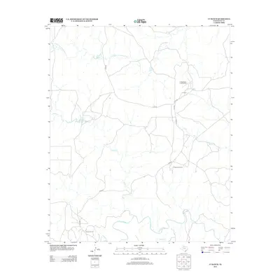
2012 Map of J Y Ranch
USGS Topo · Published 2012About this map
JY Ranch and its operations define this reach of King County, Texas, where the landscape is shaped by the winding courses of the Middle Fork Wichita River and the S Wichita River. This 2012 survey illustrates the isolated ranching infrastructure typical of the region, including the JY Ranch South Camp and the private JY Masterson Landing Field. The drainage patterns of Willow Cr and Bird Cr weave through the central terrain, eventually feeding into the larger river systems. In the southwestern corner, the Bateman Oil Field indicates the intersection of traditional cattle ranching with the mineral extraction industry. The map captures a moment of modern ranch life, documented through a network of county roads like Co RD-251 and Co RD-274 that connect these remote outposts across the prairie.
Find a feature on this map
13 named features on this map. Tap any name to fly to it.
Don’t see what you’re looking for? This feature index may not catch every label — zoom into the map to look around manually.
Map Details
Editions of this 2012 J Y Ranch Map
This is the sole edition of this map. No revisions or reprints were ever made.
Other maps of this area

1954 · Lubbock
USGS Topo · 1:250,000

1966 · Ox Yoke Creek
USGS Topo · 1:24,000

1966 · Chalk SW
USGS Topo · 1:24,000

1966 · J Y Ranch
USGS Topo · 1:24,000

1966 · Lowrance Mountain
USGS Topo · 1:24,000

1967 · Dark Canyon
USGS Topo · 1:24,000

1967 · Fourmile Hill
USGS Topo · 1:24,000
1967 · Buzzard Peak
USGS Topo · 1:24,000

1968 · Grow
USGS Topo · 1:24,000

1968 · Guthrie
USGS Topo · 1:24,000