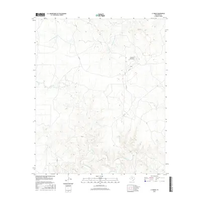
2016 Map of J Y Ranch
USGS Topo · Published 2016About this map
Middle Fork Wichita River and the South Wichita River bracket a section of the Rolling Plains in North Texas, defined by the extensive operations of the J Y Ranch. This 2016 survey shows a landscape dominated by ranching infrastructure and hydrological drainage, where the confluence of several tributaries, including Willow Creek, Bird Cr, and Newman Cr, carve through the local topography. Human presence is concentrated around the J Y Ranch-R B Masterson III Estate Airport, reflecting the modern scale of large-acreage Texas landholdings. A sparse network of unpaved corridors like Co RD 251 and Co RD 257 provides the only overland access through this cattle country, illustrating the sustained isolation and low population density of King County.
Find a feature on this map
10 named features on this map. Tap any name to fly to it.
Don’t see what you’re looking for? This feature index may not catch every label — zoom into the map to look around manually.
Map Details
Editions of this 2016 J Y Ranch Map
This is the sole edition of this map. No revisions or reprints were ever made.
Other maps of this area

1954 · Lubbock
USGS Topo · 1:250,000

1966 · Ox Yoke Creek
USGS Topo · 1:24,000

1966 · Chalk SW
USGS Topo · 1:24,000

1966 · J Y Ranch
USGS Topo · 1:24,000

1966 · Lowrance Mountain
USGS Topo · 1:24,000

1967 · Dark Canyon
USGS Topo · 1:24,000

1967 · Fourmile Hill
USGS Topo · 1:24,000
1967 · Buzzard Peak
USGS Topo · 1:24,000

1968 · Grow
USGS Topo · 1:24,000

1968 · Guthrie
USGS Topo · 1:24,000