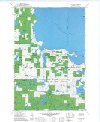
1971 Map of Jack Lake
USGS Topo · Published 1973About this map
Chippewa National Forest and the Leech Lake Indian Reservation intersect in this lake-heavy northern landscape. The massive expanse of Leech Lake dominates the north and east, featuring landforms like Pelican Island and Rogers Point. Inland, the terrain is characterized by a high density of smaller water bodies, including Wabegon Lake, Jack Lake, and Rice Lake, which sit amidst wooded areas and wetlands.
Find a feature on this map
36 named features on this map. Tap any name to fly to it.
Don’t see what you’re looking for? This feature index may not catch every label — zoom into the map to look around manually.
Map Details
Editions of this 1971 Jack Lake Map
2 editions found
Other maps of this area

1953 · Brainerd
USGS Topo · 1:250,000

1954 · Bemidji
USGS Topo · 1:250,000

1957 · Brainerd
USGS Topo · 1:250,000

1957 · Bemidji
USGS Topo · 1:250,000

1958 · Bemidji
USGS Topo · 1:250,000

1958 · Brainerd
USGS Topo · 1:250,000

1965 · Brainerd
USGS Topo · 1:250,000

1970 · Hackensack
USGS Topo · 1:24,000

1970 · Webb Lake
USGS Topo · 1:24,000

1970 · Woman Lake
USGS Topo · 1:24,000